Program Map
Please choose between the following three options:
Skip to main menu Skip to site search Continue to current page menu and contentMain page content begins here
Yellowhead Trail is becoming a freeway with 3 lanes of free-flowing traffic in each direction.
The Yellowhead Trail Freeway Conversion Program will be implemented through a combination of large and small projects that supports efficient delivery of each phase of planning, design and construction and minimizes impacts to road users, residents and businesses.
On freeways, traffic is able to flow freely because there are no traffic signals, intersections or crossings at the same level with other roads, railways or pedestrian paths.
Uninterrupted travel in eastbound and westbound directions will reduce travel delays
Improved safety with free flowing traffic
Reduced idling emissions
Improved goods and service movement
The City values public input and recognizes its importance in identifying the needs of all Yellowhead Trail road users and area residents and businesses. Each project within the Yellowhead Trail Freeway Conversion Program is being built to balance the roadway requirements with community, business and commuter needs. You can find current public engagement opportunities on each project page and visit the Program History page to learn more about the program.
On December 16, 2016, the Government of Canada and the Government of Alberta joined the City of Edmonton to announce joint funding for improving the Yellowhead Trail to better accommodate current and future traffic. The federal and provincial governments are each contributing up to $241.6 million, with the City providing remaining funding for a total of over $1 billion.
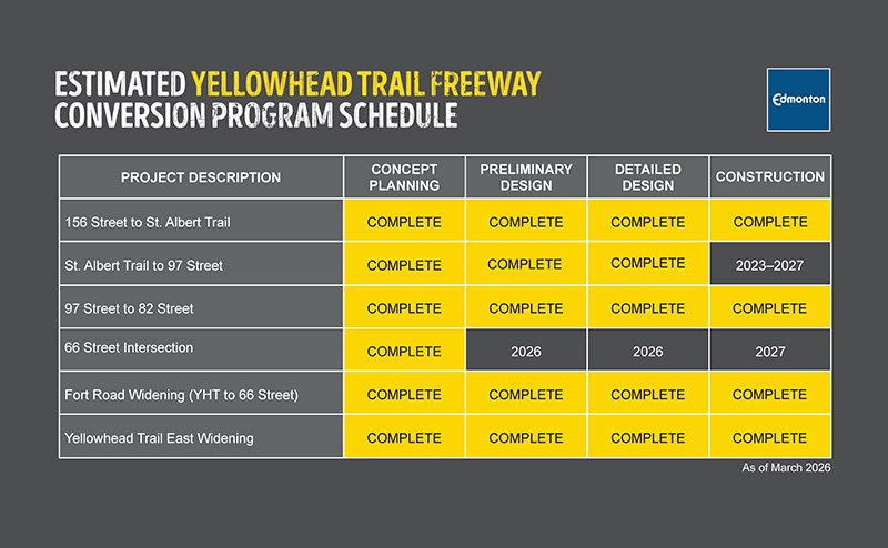
The overall freeway conversion will be complete by the end of 2027. Construction began on some roadways and areas connecting to Yellowhead Trail in 2019 but some of the larger projects on Yellowhead Trail itself are beginning in 2020 and will continue through 2027.
Yellowhead Trail Freeway Conversion Program Schedule
Various construction projects are included in the Yellowhead Trail Freeway Conversion Program with construction timing being coordinated with consideration for efficiency and to minimize impacts to the public.
Find answers for the most frequently asked questions about the Yellowhead Trail freeway conversion.
Yellowhead Trail Freeway Conversion Program will turn Yellowhead Trail into a freeway. This means 3 lanes of free flowing traffic in each direction travelling at a target speed of approximately 80 km/hr. To do this, the current signalized intersections and direct access on or off Yellowhead Trail will need to be removed.
On freeways, traffic is able to flow freely because there are no traffic signals, intersections or crossings at the same level with other roads, railways or pedestrian paths.
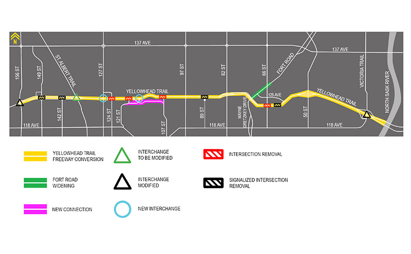
Yellowhead Trail as a freeway means the current traffic signals will be removed and road users will exit and enter Yellowhead Trail at the nearest interchange.
Interchanges are grade-separated intersections (one road passes over another) with ramps to connect them. Within our freeway conversion limits, there are currently interchanges located at 156 Street, St. Albert Trail, 97 Street, 82 Street, Fort Rd/Wayne Gretzky Drive, 50 Street and Victoria Trail.
As part of the freeway conversion, options for new interchanges are being explored between St. Albert Trail and 97 Street, and construction of a new overpass has been recommended at 66 Street. New parallel roads between some interchanges will support access to areas that previously had direct access on or off Yellowhead Trail.
Yellowhead Trail is part of the City’s inner ring road, and is a key highway connector. While big trucks and vehicles can bypass Edmonton using Anthony Henday Drive, many still need to get into and through the city.
Currently 63,000 – 81,000 vehicles use Yellowhead Trail every day. By 2047, traffic volumes are expected to increase on Yellowhead Trail to between 87,000 – 155,000 vehicles daily even with Anthony Henday open.
Turning Yellowhead Trail into a freeway was identified in the City’s Major Goods Movement Strategy for several reasons:
Yellowhead Trail is classified as a major goods movement route.
Yellowhead Trail is already experiencing delays in peak periods and mid-day on weekends. With traffic growth, delays will be even longer if improvements aren’t made.
Safety is important. On average, almost 1,000 vehicle collisions have occurred annually on Yellowhead Trail over the past decade. Having traffic flow freely, without the need to stop at traffic signals, will help prevent collisions.
After the freeway conversion, road users will exit and enter Yellowhead Trail at the nearest interchange or parallel road. None of the existing interchanges will be closed, though some may be modified to accommodate traffic pattern changes in the area.
All private accesses that currently go directly onto Yellowhead Trail will also be closed.
Interchanges are grade-separated intersections (one road passes over another) with ramps to connect them. Within our freeway conversion limits, there are currently interchanges located at 156 Street, St. Albert Trail, 97 Street, 82 Street, Fort Rd/Wayne Gretzky Drive, 50 Street and Victoria Trail. As part of the freeway conversion, options for new interchanges are being explored between St. Albert Trail and 97 Street, and construction of a new overpass has been recommended at 66 Street. New parallel roads between some interchanges will support access to areas that previously had direct access on or off Yellowhead Trail.
Funding commitments were made by the federal and provincial governments and the City for the completion of this work.
The total budget is around $1 billion dollars. The federal and provincial governments will each be contributing approximately $242 million with the City covering the remainder.
Construction started in 2019, primarily on roadways and areas surrounding Yellowhead Trail. The overall freeway conversion will be complete by the end of 2027. Construction began on some roadways and areas connecting to Yellowhead Trail in 2019 but some of the larger projects on Yellowhead Trail itself are beginning in 2020 and will continue through 2027.
Land requirements along the corridor will be identified in the individual project design plans. Each developed design plan, whether it is still in the concept stage or final, can be viewed on our project pages.
The City always considers property impacts when planning projects and is committed to working with property owners to reduce and minimize these impacts. If there is potential land impact to your property, you will be contacted by the City’s Real Estate Branch.
Property assessment is done through the City’s Assessment and Taxation Branch. For questions about your specific property, you can call 311 and mention you have a question about property values and assessments or email assessment@edmonton.ca.
You can call 311 or email yellowhead@edmonton.ca for more information.